
PR8
The other Madeira - red cliffs, big sky, no shade
Vereda da Ponta de São Lourenço strips out the green and gives you the volcanic spine of the island. 7 km out-and-back along the eastern peninsula with Atlantic vistas on three sides and not a tree in sight.
Curated by
Filipe Pereira
Founder & Lead Curator
Issued 2026-05-16
Valid through June 2026
01 · At a glance
The vitals
What you need to know about Vereda da Ponta de São Lourenço before you book or set out.
Distance
7 km
Duration
2.5-4 h
Elevation gain
150 m
Difficulty
Easy-Moderate
Exposure
4/5
Type
Vereda (coastal)
Status, May 2026
Open
Open year-round. The peninsula was hit by wildfire in 2024 but vegetation has recovered enough for the trail to reopen fully. No SIMplifica capacity issues - the fee gates traffic but the trail itself is wide and absorbs volume well.
Best season
Year-round - avoid windy days
May through October has the best light and calmest mornings. Avoid days with strong northeast wind (above 50 km/h) - the exposed clifftops become unsafe. Winter is fine but seas are rougher and dramatic. Always start early in summer - no shade means 30°C+ surface temperature by 11:00.
“If you only do one hike in Madeira and it is not green, do this one. The contrast is the point.”
02 · Getting to the trailhead
How to reach the start
Map placeholder
Start: Baía d'Abra · End: Ponta do Furado
By car from Funchal
About 40 minutes via VR1 east, exit Caniçal, continue past the tunnel to Baía d'Abra car park at the road end. Last 4 km is winding but paved.
Parking
Baía d'Abra car park, free, holds about 80 cars. Fills by 10:30 in summer. Overflow on roadside is policed - ICNF fines €60 for unauthorised parking.
Public transport
Horários do Funchal bus 113 from Funchal to Caniçal village. From the village you walk 4 km along the road to the trailhead - hot and not pleasant. Most hikers drive or get an operator.
Taxi or transfer
Funchal to Baía d'Abra one-way is €25-35. The drive back includes a stop at Prainha or the Caniçal old town if you ask.
Operator pickup
Protocol partners run PR8 as a half-day. The drive there + walk + return fits 9:00-14:00. Some pair it with whale-watching from Caniçal harbour in the afternoon.
Tip from Filipe
The car park has zero shade. If you arrive at 09:00 and leave at 12:30, your car will be a furnace. Park as far back as you can and crack windows. The free Casa do Sardinha shelter at km 3.5 is the only shade on the whole route.
Driving yourself
Madeira rental from Funchal Airport, around €25-40/day in May
We use DiscoverCars to compare local agencies. Trailhead access on most PR routes is easier with a car.
https://www.discovercars.com/portugal/funchal?a_aid=Madeirahiking¤cy=eur&utm_source=Madeirahiking&utm_medium=link&utm_campaign=pdf-pr8
03 · Route walkthrough
Section by section
Distances, landmarks, and what to expect underfoot.
0.0 - 0.5 km
0:15
Car park to the Pedra Furada saddle
Wide gravel path drops gently to the first saddle. Bench with views back over Caniçal. Pedra Furada is the windowed-rock formation visible to the north - photo stop.
0.5 - 1.5 km
0:30
First exposed ridge
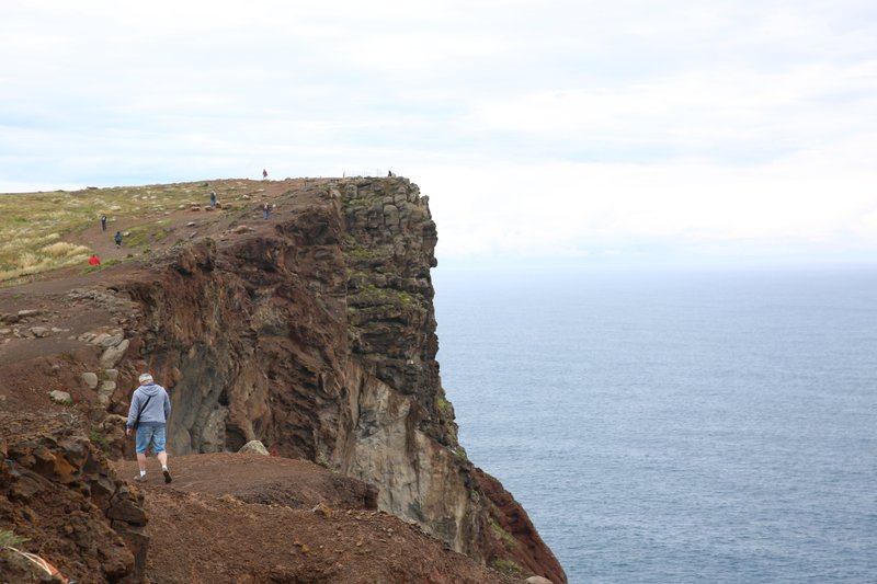
The trail climbs over the spine of the peninsula. Sea cliffs on the south side drop 70 m, less protected on the north side. Wind funnels through this section - if it is windy here, it will be worse further on.
Exposure 4/5. Stay on the marked path - the cliff edges are unstable basalt.
1.5 - 3.0 km
0:40
Rolling middle section
The trail flattens and crosses red volcanic plateau. Sparse vegetation, lots of lizards, the occasional Madeira buzzard overhead. Two minor descents into shallow gullies. Mid-morning light makes the cliffs glow.
3.0 - 3.5 km
0:15
Final climb to Casa do Sardinha
Last push up to the former lighthouse-keeper's house, now an ICNF visitor shelter. Free water (in summer), shaded picnic tables, bathrooms. The wooden viewing platform extends to the eastern tip.
3.5 km
Stop
Ponta do Furado - the easternmost point
View east to the Desertas Islands (uninhabited nature reserve). Cliff drops 90 m to the sea. Casa do Sardinha at this turnaround point is the only shade and the only water. Eat lunch, refill, head back.
3.5 - 7.0 km
1:30
Return via the same route
Same trail back. The light direction changes everything - the morning shadows are gone, the cliffs look different. The final climb out of the Pedra Furada saddle to the car park is the only hard uphill of the route.
04 · Gear and safety
What to bring and when to bail
Required
- Sun hat with a brim - the only effective shade on the route
- Sunscreen SPF 50+, reapplied at Casa do Sardinha
- Sunglasses - reflected glare off the basalt is intense
- Water: 2-3 L in summer, 1.5 L in cooler months
- Windproof shell - wind chills exposed skin even on warm days
- SIMplifica permit
Recommended
- Buff for neck protection
- Long-sleeve sun layer (mineral-coated synthetic)
- Trekking pole for the gully descents
- Camera with polarising filter for the ocean shots
- Snacks - Casa do Sardinha does not sell food
Heat is the underrated hazard
No shade for 3 km each way. Surface temperature exceeds air temperature by 8-10°C on basalt. In July-August, plan to be off the trail by 11:30 or after 16:00. Heat stroke is the single most common medical incident on PR8.
Wind decides the route
On windy days the cliff sections become genuinely dangerous - gusts above 70 km/h have pushed hikers off the path. Check ipma.pt for Ponta de São Lourenço wind forecast specifically. If sustained wind exceeds 50 km/h, postpone.
Cliff edges are not stable
The basalt erodes constantly. The marked path stays 1-2 m back from the actual edge for a reason. Do not lean over for the photo. Five fatal falls in the last decade are public record.
Signal is good but isolated
Cell coverage is strong across the peninsula thanks to the Caniçal tower. But the trail is exposed - if you go down, you are visible from a distance but reaching you takes time. INEM helicopter response is the only quick option.
Emergency: 112
Coverage along this route is patchy. Walk-out points: Casa do Sardinha at km 3.5 (water + shelter + bathroom, staffed in summer). Otherwise back to the Baía d'Abra car park. There is no mid-route exit.
05 · Fees and booking
Two paths to the trailhead
Path A · DIY
Book on SIMplifica
€4.50
per person
- Open simplifica.madeira.gov.pt and log in.
- Search "Ponta São Lourenço" or PR8.
- Pick your date and number of people. No advance limits - usually bookable same-day.
- Pay €4.50/person by card.
- Save confirmation offline. Rangers patrol the trailhead morning and afternoon.
Path B · Protocol operator
Skip the portal
€3.00
per person, fee included in tour
On PR8, the protocol-operator value is less about the €1.50 fee saving and more about avoiding the parking lottery and the heat. Most operators run PR8 as a 7:30 start to be off the cliffs before midday. The included transfer + early start is worth €15-25 in real terms.
Protocol operators running this trail
Madeira Local Guide - Paulo Jesus
PT/EN · Private only · €66-114
+351 XXX XXX XXX
tripadvisor.com/madeira-local-guide
Up Mountain Madeira
PT/EN/DE · Max 8 people · €40-120
+351 925 964 335
upmountainmadeira.com
Explore Nature
PT/EN · Small groups · €27-80
+351 964 851 693
explorenature.pt
Path C · Marketplace listing
Ponta de São Lourenço Guided Walk
From €35 · 4-5 hours · ⭐ 4.8
If you cannot reach a protocol partner, GetYourGuide aggregates tours from multiple operators with free 24h cancellation. Independent listing - not a preferred channel for this trail.
https://www.getyourguide.com/madeira-l67/hiking-tc71/?partner_id=2VCHGBU&utm_medium=online_publisher&cmp=pdf-pr8
Trailhead transfer (no car needed)
Caniçal – Ponta São Lourenço Hiking Transfer · From €20
PR8 Ponta de São Lourenço Transfer · From €20
06 · After the hike
What to do with the rest of the day
Pair it with
Caniçal harbour
Tuna-fishing village a 10-minute drive from the trailhead. Lunch at any of the seafood restaurants on the harbour. Whale-watching boats depart from here in summer.
Prainha beach
Madeira's only natural sand beach (the rest are pebble or imported). Five minutes from Caniçal. Sheltered cove, calm water - the right place to cool off after the heat of the peninsula.
Machico old town
Twenty minutes back toward Funchal. Where the Portuguese first landed in 1419. Pastelaria culture, the João Gomes river walk, and a quiet alternative to Funchal for an afternoon.
Common questions
Can I do PR8 in flip-flops?
Technically yes, the path is gravel and dirt. But the basalt is sharp where it weathers, your feet will burn on hot rock, and a twisted ankle 3 km from the car is a long walk. Closed shoes minimum.
Are there bathrooms on the trail?
One set at Casa do Sardinha (km 3.5), open in summer. Otherwise nothing. The car park has none. Plan accordingly.
Is PR8 dog-friendly?
Dogs are allowed on lead. But - no shade, no water, hot basalt that burns paws. Most owners regret it. If you do bring a dog, carry water for them and aim for cooler hours.
How long does the full out-and-back actually take?
Quick hiker: 2:30. Average pace with photos: 3:00-3:30. With a long lunch at Casa do Sardinha: 4:00. Operators typically budget 4 hours including transfer.
Live trail status
madeirahiking.org/trails/pr8
Conditions change. The live page is verified against ICNF announcements and re-checked on a rolling cadence. Refresh before you set out.
May 2026 edition · issued 2026-05-16 · MadeiraHiking.org · Curated by Filipe Pereira
Scan for live status