
PR2
South to north coast, one mountain crossing
Vereda do Urzal from Curral das Freiras to Boaventura: 10.6 km traverse over the Boca das Torrinhas (1,450 m), descending to the north coast. Currently partially open - the south-side ascent is the workable portion.
Curated by
Filipe Pereira
Founder & Lead Curator
Issued 2026-05-16
Valid through June 2026
01 · At a glance
The vitals
What you need to know about Vereda do Urzal before you book or set out.
Distance
10.6 km
Duration
4-5 h
Elevation gain
931 m
Difficulty
Moderate
Exposure
3/5
Type
Vereda (mountain crossing)
Status, May 2026
Partially Open
Partially open in 2026. The Curral das Freiras → Boca das Torrinhas ascent is accessible. The northern descent to Boaventura has restricted sections after winter landslides. Check ICNF updates before committing - this is a logistical trail (different start and end villages) so partial-access changes the day fundamentally.
Best season
Spring and autumn
May-June and September-October give the most stable mountain weather. Winter brings fog at the pass and can make the high crossing genuinely dangerous. Summer is hot on the south side and shrouded on the north - the trail is rarely "easy" in any season.
“Two completely different Madeiras in one day - the southern bowl, the high pass, the wet green north.”
02 · Getting to the trailhead
How to reach the start
Map placeholder
Start: Curral das Freiras · End: Lombo do Urzal (Boaventura)
By car from Funchal
About 45 minutes via VR1 then the dramatic ER107 north into the Curral das Freiras valley. The "Valley of the Nuns" sits in a volcanic amphitheatre at 519 m.
Parking
Curral das Freiras village square, free street parking. Local cafe doubles as the trail info point.
Public transport
Horarios do Funchal bus 81 runs hourly from Funchal to Curral das Freiras. Boaventura return (if you complete the full crossing) needs SAM bus 103 - one connection back to Funchal via Santana.
Operator pickup
Protocol partners run PR2 as a logistics-managed crossing: drop you at Curral, pick you up at Boaventura. This solves the transport problem that kills the DIY version when buses align poorly.
Taxi or transfer
One-way taxi Curral das Freiras to Boaventura is €60-80. Pre-arrange both ends.
Tip from Filipe
Until full reopening, treat PR2 as an out-and-back from Curral das Freiras to the Boca das Torrinhas viewpoint (km 5.5) rather than a full crossing. Saves the logistics problem and still delivers the best view of the route.
Driving yourself
Madeira rental from Funchal Airport, around €25-40/day in May
We use DiscoverCars to compare local agencies. Trailhead access on most PR routes is easier with a car.
https://www.discovercars.com/portugal/funchal?a_aid=Madeirahiking¤cy=eur&utm_source=Madeirahiking&utm_medium=link&utm_campaign=pdf-pr2
03 · Route walkthrough
Section by section
Distances, landmarks, and what to expect underfoot.
0.0 - 2.0 km
1:00
Curral das Freiras to the lower valley
The trail leaves the village past chestnut groves (Curral is famous for chestnut everything). Steep cobbled path climbs through agricultural terraces - the lower 200 m of elevation gain.
2.0 - 4.5 km
1:30
Steady climb to Pinaculo
Trail steepens into open hillside. Views back down to the valley get progressively more dramatic. Path is well-worn cobble and dirt.
Exposed slope - no shelter if weather turns. Carry a windproof.
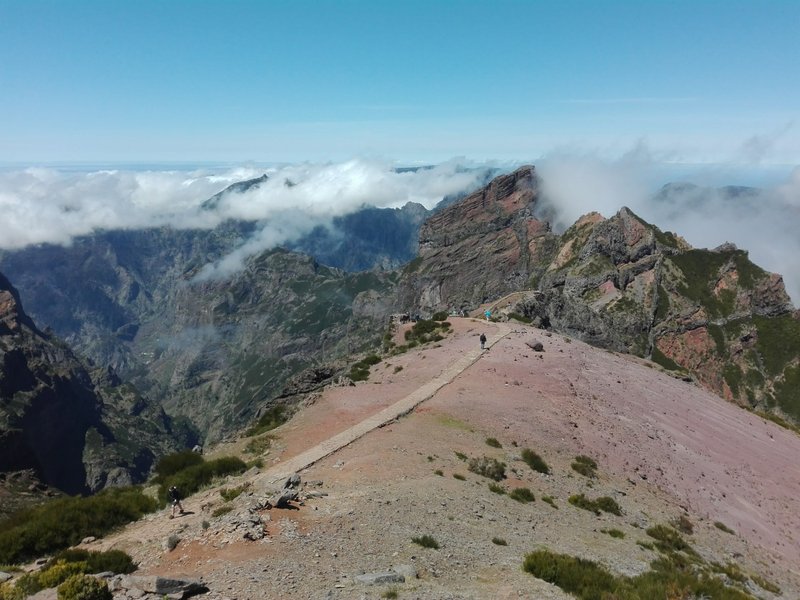
4.5 - 5.5 km
0:30
Boca das Torrinhas pass
Reach the high col at 1,450 m. Sharp panorama south over Curral, north over the Boaventura valley. The signpost here marks the partial-opening turnaround - check current ICNF status.
5.5 - 8.5 km
1:00
North-side descent (when open)
Drops steeply through wet north-facing forest. Cobbles can be slick. Visibility often poor here - the cloud cap parks on this side.
Knee-stress on the descent. Trekking poles help.
8.5 - 10.6 km
0:50
Lombo do Urzal to Boaventura
Final agricultural section through vineyards and the Lombo do Urzal hamlet. Ends at the Boaventura ER101 road - the pickup point.
04 · Gear and safety
What to bring and when to bail
Required
- Hiking boots with good ankle support
- Layers - 800 m of altitude gain crosses two microclimates
- Windproof shell
- Water: 2 L (no springs en route)
- Trekking poles for the north descent
- SIMplifica permit
Recommended
- Hat for the exposed south side
- Spare socks if doing the full crossing
- Snacks for the pass
- Phone with offline maps - signal patchy at altitude
- Cash for the Curral chestnut bakery on the return
Weather flips at the pass
Boca das Torrinhas sits exactly where southern dry air meets northern wet air. Visibility can drop from 10 km to 100 m in minutes. Turn back if cloud forms below the pass.
Partial opening restrictions
Until the full route reopens, do not push past the official turnaround point - the closed sections have unstable ground. Rangers patrol the pass on weekends.
Elevation gain is substantial
931 m in 5.5 km of climbing is steeper than it sounds on the map. Pace yourself - this is a half-day even for fit hikers.
Signal patchy at altitude
Vodafone has the best coverage along the south side. The pass and north slope drop to no signal. 112 still works on fallback.
Emergency: 112
Coverage along this route is patchy. Walk-out points: back to Curral das Freiras (km 0). The pass itself has no shelter. If you reach the north side and need exit, Lombo do Urzal hamlet at km 8.5 is the first staffed point.
05 · Fees and booking
Two paths to the trailhead
Path A · DIY
Book on SIMplifica
€4.50
per person
- Open simplifica.madeira.gov.pt and log in.
- Search "Urzal" or PR2. Confirm current partial-opening status.
- Pick your date and number of people.
- Pay €4.50/person by card.
- Save the confirmation and screenshot the latest ICNF closure notice.
Path B · Protocol operator
Skip the portal
€3.00
per person, fee included in tour
PR2 is the canonical "operator-makes-this-possible" trail. DIY requires solving the Curral-to-Boaventura transport puzzle, which only works on specific bus days. Operators handle it as a single product and know which sections are actually open.
Protocol operators running this trail
Madeira Local Guide - Paulo Jesus
PT/EN · Private only · €66-114
+351 XXX XXX XXX
tripadvisor.com/madeira-local-guide
Up Mountain Madeira
PT/EN/DE · Max 8 people · €40-120
+351 925 964 335
upmountainmadeira.com
Explore Nature
PT/EN · Small groups · €27-80
+351 964 851 693
explorenature.pt
Path C · Marketplace listing
Browse Guided Madeira Hiking Tours
From €30 · Various · ⭐ 4.7
If you cannot reach a protocol partner, GetYourGuide aggregates tours from multiple operators with free 24h cancellation. Independent listing - not a preferred channel for this trail.
https://www.getyourguide.com/madeira-l67/hiking-tc71/?partner_id=2VCHGBU&utm_medium=online_publisher&cmp=pdf-pr2
06 · After the hike
What to do with the rest of the day
Pair it with
Curral das Freiras viewpoint (Eira do Serrado)
On the drive in, the Eira do Serrado lookout 800 m above the village shows the full volcanic amphitheatre. Five-minute stop, big payoff.
PR1 Pico ridge from Areeiro
PR2 ends near Boaventura; the high ridge from Areeiro to Ruivo runs along the same mountain massif. Different trail, same skyline.
Santana traditional houses
On the drive back from Boaventura to Funchal via the north-coast road, Santana is the obvious lunch stop.
Common questions
Can I do PR2 as an out-and-back to avoid logistics?
Yes - turn around at the Boca das Torrinhas viewpoint (km 5.5). Adds elevation gain but solves the pickup problem. Best for current partial-opening status.
What if the trail fully reopens mid-trip?
Check ICNF and our trail-status page weekly. When the north descent reopens, the full crossing becomes a workable 5-6 hour day with operator logistics.
Is PR2 a good first Madeira hike?
No. The elevation gain, weather exposure, and logistics make it a third or fourth hike on the island, not the first.
Live trail status
madeirahiking.org/trails/pr2
Conditions change. The live page is verified against ICNF announcements and re-checked on a rolling cadence. Refresh before you set out.
May 2026 edition · issued 2026-05-16 · MadeiraHiking.org · Curated by Filipe Pereira
Scan for live status