
PR5
The forest crossing nobody talks about
Vereda das Funduras from the Portela viewpoint down to Maroços: 8.7 km through Laurisilva forest with constant views of Penha d'Águia rock. The east-Madeira alternative when PR8 is windy and PR9 is full.
Curated by
Filipe Pereira
Founder & Lead Curator
Issued 2026-05-16
Valid through June 2026
01 · At a glance
The vitals
What you need to know about Vereda das Funduras before you book or set out.
Distance
8.7 km
Duration
3-4 h
Elevation gain
438 m
Difficulty
Moderate
Exposure
2/5
Type
Vereda (coastal hills)
Status, May 2026
Open
Open year-round 2026. No current restrictions. Permit demand is light - usually bookable same-day. The Portela trailhead car park can fill on weekends because of the viewpoint traffic, but the trail itself stays quiet.
Best season
Year-round, especially spring
Spring (April-June) brings the cleanest light through Laurisilva. Summer is hot on open hillsides. Autumn delivers stable weather and the chestnut harvest stories from Maroços at the trail end.
“A forest hike that finishes in a wine village - very few people, very real Madeira.”
02 · Getting to the trailhead
How to reach the start
Map placeholder
Start: Portela Viewpoint · End: Maroços
By car from Funchal
About 30 minutes via VR1 east to Machico, then up the ER102 to Portela (660 m). Mountain road, the last 4 km is winding.
Parking
Free at the Portela viewpoint car park. Restaurant and bar at the trailhead for the return.
Public transport
SAM bus 53 runs Funchal-Portela 3-4 times daily. From Maroços (end of trail), bus 78 back to Machico, connect to Funchal.
Operator pickup
Protocol partners can run PR5 with the Portela-to-Maroços transport built in. Often combined with a Machico old town lunch.
Taxi or transfer
Funchal to Portela one-way is €30-35. End-of-trail Maroços to Funchal is similar.
Tip from Filipe
PR5 is the quietest fee-required trail in east Madeira. If PR8 (Ponta de São Lourenço) is too windy or you want forest over coastal, this is the swap. Most operators do not push it, which is exactly why it stays uncrowded.
Driving yourself
Madeira rental from Funchal Airport, around €25-40/day in May
We use DiscoverCars to compare local agencies. Trailhead access on most PR routes is easier with a car.
https://www.discovercars.com/portugal/funchal?a_aid=Madeirahiking¤cy=eur&utm_source=Madeirahiking&utm_medium=link&utm_campaign=pdf-pr5
03 · Route walkthrough
Section by section
Distances, landmarks, and what to expect underfoot.
0.0 - 1.5 km
0:35
Portela viewpoint to the first forest section
Start at the Portela panoramic terrace (full view of Penha d'Águia rock dominating the horizon). Trail drops west into the forest on a clear dirt path.
1.5 - 4.0 km
1:00
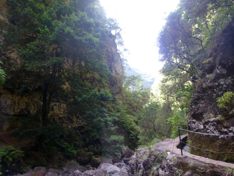
Forest immersion
Deep Laurisilva - tree heather and laurel. Several small streams cross the path. Stable rocky underfoot. Glimpses of Penha d'Águia through the canopy.
4.0 - 6.0 km
0:50
Hillside traverse with views
Trail opens onto sunny hillsides above Machico valley. Patchwork of agricultural terraces below. Some narrow sections with unfenced drops.
Watch the footing on the open hillside - dry path is hard, wet path is slick.
6.0 - 8.0 km
0:50
Descent to Maroços
Cobbled path drops through agricultural terraces - vines, chestnut, vegetable plots. Local farmers occasionally on the path.
8.0 - 8.7 km
0:15
Maroços village
End at Maroços main road. Small village cafe at the trail exit. From here, bus or pickup to Machico (4 km) or onward to Funchal.
04 · Gear and safety
What to bring and when to bail
Required
- Hiking shoes with grip - mixed surfaces
- Sun protection - some open hillside sections
- Water: 1.5 L
- Light rain jacket
- SIMplifica permit
Recommended
- Trekking pole for the descent
- Camera - Penha d'Águia is a striking subject all day
- Cash for the Portela bar on return
- Snacks for mid-route
The descent is the work
438 m of elevation loss over 5 km is gentle on paper, hard on knees after 2 hours. The cobbled sections in Maroços are the slickest part - careful here.
Open hillside sections
A few exposed traverses with drops of 20-30 m. Marked but unfenced. Stay on the path.
East Madeira weather is local
Portela sits in a transition zone. Cloud can park on Penha d'Águia while Machico stays clear. Bring rain gear regardless of city forecast.
Signal mostly good
Strong coverage along most of the route - east Madeira has good network density. Brief dropouts in the deepest forest sections.
Emergency: 112
Coverage along this route is patchy. Walk-out points: Portela trailhead (km 0) or Maroços (km 8.7). No mid-route exit on the lower forest section.
05 · Fees and booking
Two paths to the trailhead
Path A · DIY
Book on SIMplifica
€4.50
per person
- Open simplifica.madeira.gov.pt and log in.
- Search "Funduras" or PR5.
- Pick your date. Same-day usually available.
- Pay €4.50/person by card.
- Save the confirmation.
Path B · Protocol operator
Skip the portal
€3.00
per person, fee included in tour
For PR5, the operator value is the point-to-point logistics (Portela to Maroços) and the local lunch pairing in Machico old town. The fee saving is modest; the day-experience saving is substantial for non-drivers.
Protocol operators running this trail
Madeira Local Guide - Paulo Jesus
PT/EN · Private only · €66-114
+351 XXX XXX XXX
tripadvisor.com/madeira-local-guide
Up Mountain Madeira
PT/EN/DE · Max 8 people · €40-120
+351 925 964 335
upmountainmadeira.com
Explore Nature
PT/EN · Small groups · €27-80
+351 964 851 693
explorenature.pt
Path C · Marketplace listing
Browse Guided Madeira Hiking Tours
From €30 · Various · ⭐ 4.7
If you cannot reach a protocol partner, GetYourGuide aggregates tours from multiple operators with free 24h cancellation. Independent listing - not a preferred channel for this trail.
https://www.getyourguide.com/madeira-l67/hiking-tc71/?partner_id=2VCHGBU&utm_medium=online_publisher&cmp=pdf-pr5
06 · After the hike
What to do with the rest of the day
Pair it with
Machico old town
The first Portuguese landing site in Madeira (1419). Pastel-coloured fishermen's houses, the João Gomes river walk, traditional restaurants.
Penha d'Águia summit
The dramatic rock you spend PR5 looking at. There is a separate steep trail to its top from Faial - a 2-hour adventure for fitter hikers.
PR8 Ponta de São Lourenço
The next valley east. Both can be done on the same trip but not the same day - too much driving.
Common questions
How does PR5 compare to PR8?
PR5 is forest, shaded, moderate. PR8 is coastal, exposed, no shade. Different experiences. PR5 is better for hot summer days.
Is the descent hard on the knees?
438 m loss over 5 km is gentle by Madeira standards. Trekking pole helps but most hikers manage without.
Can I do it in reverse (Maroços to Portela)?
Yes but it becomes a sustained 438 m climb in 5 km. Same trail, much harder. Most operators run Portela → Maroços.
Live trail status
madeirahiking.org/trails/pr5
Conditions change. The live page is verified against ICNF announcements and re-checked on a rolling cadence. Refresh before you set out.
May 2026 edition · issued 2026-05-16 · MadeiraHiking.org · Curated by Filipe Pereira
Scan for live status